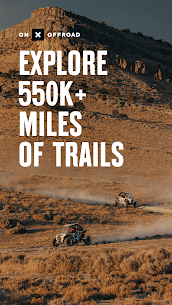
This GPS mapping app allows you to easily locate the off-road trails that you are looking for, whether you want to explore new areas or discover what is available nearby. You can filter 615K miles nationwide trails by accessibility for 4×4, dirt bikes, 4×4, ATV/Quads and snowmobiles.
>Navigate without Cell Coverage
You can save offline maps to take your adventure and custom maps along with you when you aren’t connected to the internet. The onX Offroad app turns your phone into an offline GPS device. It uses your phone’s internal GPS. Follow the blue dot to navigate offline and know where to go to find your way home, wherever it is at night.
With our Library of Map Data, Adventure is Just a Tap Away
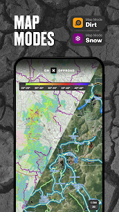
Our color-coded basemap is based on map data sourced by USFS, MVUM and BLM. It includes off-road trails and Public Land boundaries. Recreation points are included to allow you to quickly scan for open roads near you and locate campgrounds or camping sites. To locate hiking trailsheads, trailer parking, fuel stations, boat launches, and other information, tap anywhere on the map. View your maps in 3D or topo, satellite imagery or a hybrid to visualize the terrain and mountains.
>Private Property Maps with Boundaries-Elite Only
To find more off-road access, make your maps Elite. This will allow you to see data and private property boundaries for the entire country. With our Private Land Map Layer, you will always know where you can legally offroad and camp. You can also find out who owns the property adjacent to an easement for OHV trails.
>Plan, Record and Save Your Trips.
Drop Waypoints to save points-of-interest on your maps and share them with others. Go and Track records saves speed, distance, location and leaves a breadcrumb track so you can always find your way back. You can also share your ride with your friends.
>Off-Road Trails in Your Vehicle’s Dash
Android Auto compatibility allows you to enjoy hands-free navigation, view off-road trails, and maps in-dash. Android users have the ability to view their in-dash maps 3D when in service. *
> PREMIUM & ELITE OFFROAD FEATURES:
>Private land layer-ELITE ONLY: National private property maps, boundaries, ownership information and acreage.
More than 985 million acres of public land in the United States
More than 61,000+ miles of motorized roads, trails, and off-road routes for 4×4, Side by side, dirtbikes and dual sport, ATV, Quads and Overlanding, as well as snowmobiling
More than 24K topographic maps, 3D maps and other maps covering the whole U.S.
More than 550,000 Recreation Icons to point of interest, including:
>Gas and non-ethanol fuel stations
>Trailer parking
> Backcountry cabins and lookouts
>Access to swimming and fishing
>Leading hiking and biking trails
>Designated camping areas and campsites, campgrounds
>Hot Springs, Breweries and Much More
Save unlimited offline maps for offline navigation with no cell service
To plan and share your adventures, mark points on your route using photo Waypoints.
Track your journeys (location, speed and distance) and share them with your friends.
>Locate-free camping, car camping and dispersed camping
>Active and historical wildfire layer to plan safe adventures
> Weather forecasts for the next 7 days and localized weather conditions
>Line, distance and area measurement tools
>Coordinates and compass to guide you wherever you scroll or roll
> TERMS AND CONDITIONS OF USE
https://www.onxmaps.com/tou
> FEEDBACK:
OnX is a company that helps you explore new places with confidence knowing that you have onX Offroad.
[email protected] is available to help you with any problems or suggestions for what you would like to see next in the app. We would love to hear from your.