Handy GPS is the perfect companion for any outdoor adventure. Handy GPS is the perfect companion for your next outdoor adventure. There is no setup or user account required. Just install the GPS, turn it on and go!
This app is a powerful navigational tool that can be used for outdoor sports such as hiking, tramping and mountain biking. It is also useful in surveying, mining and archaeology as well as forestry applications. It is easy to use, and it works in remote areas without the need for network connectivity. You can use it with your paper topographic map and in UTM coordinates.
It is a trial version that is free and can only store 3 waypoints and 40 track log points. The trial version can be used for as long as needed. However, if you love this app, you should purchase the paid version of Handy GPS to unlock unlimited features and many more. Thanks!
BASE FEATURES
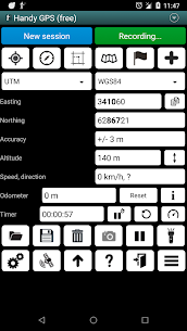
* Displays current coordinates, altitude and speed as well as the distance traveled in metric, imperial/US or nautical units.
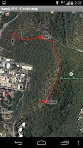
* Stores your current location as waypoints and records a track log showing where you have been on a map.
* Data can be exported to and imported into KML or GPX files.
* Allows manual entry in UTM, MGRS, and lat/lon waypoints.
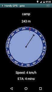
* Guides you to a waypoint by using the “Goto”, and can optionally sound an alarm when you get close.
* Can be used on devices that use magnetic field sensors.
* Calculates the local geoid offset automatically to improve altitude accuracy
* Includes support for the WGS84 global datum and common Australian map grids. WGS84 can be used in the US for NAD83 maps.
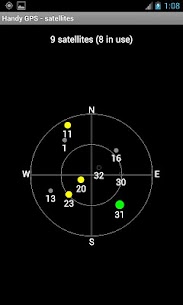
* Graphically displays GPS satellite locations and signal strengths.
* Can display simple or MGRS grid references.
* Can calculate direction and distance from one waypoint to another.
* An optional timer line is available to track your walk duration and calculate your average speed.
* This developer has thoroughly tested the system on numerous off-track walks.
EXTRA FEATURES ARE ONLY AVAILABLE IN THE PAID VERSION
* No advertisements
* Unlimited number of track log points and waypoints
* Offline maps
* Custom datums
* Elevation profile.
* Record voice notes and take photos from the app.
* Send an SMS or email your location to a friend.
* UK Grid Refs.
* GPS averaging to increase location accuracy
* Sun rise and sun set times.
* Export tracklogs and waypoints to a CSV file.
* Use distance and bearing to project waypoints
* Calculate length, area, elevation change, and distance from tracklog.
* Compute calories.
PERMISSIONS (1) GPS – to locate you, (2) Network Access – to access standard map layers, OSM tiles, and (3) SD Card Access – to store and load waypoints and tracklogs. (4) Camera access* to take photos, (5) Prevent your phone from going to sleep so that the proximity alarm can work, (6) Control flashlight from within the app to turn on/off the flashlight, and (7) Record audio to make voice memos*. * Only available in the full version of the app
DISCLAIMER – You use this app at you own risk. This app is not responsible for any injuries or loss that you may sustain. Batteries in mobile devices can go flat. Safety is a priority when taking long and distant hikes. A battery bank is recommended as well as an alternative navigation method such a paper map or compass.