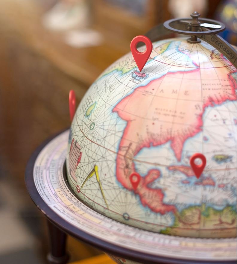
Are you curious about how to harness the power of Google Earth to measure distance and area? Google Earth isn’t just a tool for exploring the world from the comfort of your own home; it’s also a powerful platform for making precise measurements.
In this article, we’ll delve into how you can utilize Google Earth to accurately measure distance and area, step-by-step instructions for doing so, the benefits and limitations of this method, as well as some helpful tips to ensure accurate measurements. Whether you’re a student, a professional, or simply an enthusiast, understanding how to make the most of Google Earth for measurement purposes can be incredibly beneficial. So, let’s explore the ins and outs of using Google Earth for measuring distance and area, and discover the potential it holds for your own projects and explorations.
What Is Google Earth?
Google Earth is a powerful geospatial tool that provides users with access to satellite imagery, mapping, and geographical data.
It allows individuals to explore the world from various perspectives, offering high-resolution images of nearly every corner of the globe. Through its mapping features, users can view specific locations, terrain, and landmarks, making it an invaluable resource for research, navigation, and education.
Google Earth’s integration of geospatial data enables users to analyze and understand spatial patterns, environmental changes, and urban development, empowering them to make informed decisions and explore the Earth in unprecedented detail.
How Can You Use Google Earth to Measure Distance?
Utilizing Google Earth to measure distance offers a convenient way to calculate geographical dimensions using mapping technology and coordinates.
The process involves using the coordinate tool to pinpoint the starting and ending locations. Once the coordinates are set, Google Earth then overlays the locations on its digital map, allowing users to visualize the distance accurately. The mapping technology employed by Google Earth provides detailed satellite images and terrain information, ensuring precise measurements.
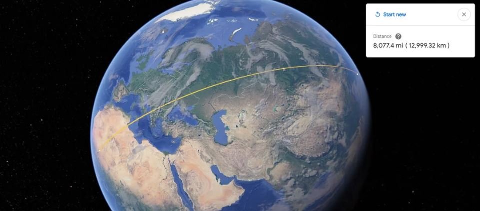
The software calculates distances using the line measurement tool, which allows users to trace the path between two points and obtain the exact distance in various units such as kilometers, miles, or nautical miles.
What Are the Steps to Measure Distance on Google Earth?
When measuring distance on Google Earth, users can follow a simple set of steps to access the necessary tools and perform accurate measurements for navigation and mapping purposes.
Begin by opening Google Earth and locating the area for which you want to measure the distance. Then, click on the ‘Ruler’ icon located in the toolbar at the top of the screen. Next, select the ‘Distance’ option and click on the starting point for the measurement. Continue to click on the points along the path you want to measure, and the distance will be displayed in the bottom right corner. You can also change the measurement units from kilometers to miles or other options based on your preference. This feature makes Google Earth a valuable tool for those needing precise and efficient distance measurements.
How Can You Use Google Earth to Measure Area?
The functionalities of Google Earth extend to measuring area, enabling users to conduct land surveying and analyze geographical features from an aerial view.
This capability allows professionals and enthusiasts to accurately measure the area of a parcel of land, assess the dimensions of geographic features, and obtain precise calculations for various purposes. Land surveyors can leverage Google Earth to gather data for boundary delineation and property evaluation.
Aerial view analysis using Google Earth provides a valuable tool for assessing terrain, identifying landforms, and examining changes over time, making it an indispensable resource for environmental and urban planning projects.
What Are the Steps to Measure Area on Google Earth?
To measure area on Google Earth, users can follow specific steps to access geodetic tools and perform precise calculations for analyzing landscapes and geographic areas.
This involves first opening Google Earth and navigating to the desired location using the search bar. Once the location is set, users can utilize the ‘Ruler’ tool from the menu bar to measure the perimeter of the area they wish to analyze.
By clicking on the ‘Polygon’ option, users can then outline the boundaries of the area to pinpoint the specific region of interest. Google Earth provides accurate measurements taking into account the Earth’s curvature, ensuring precision in the calculated area.
What Are the Benefits of Using Google Earth for Measuring Distance and Area?
Utilizing Google Earth for measuring distance and area offers numerous benefits, including spatial analysis capabilities and 3D visualization for accurate geospatial assessment.
The platform also provides historical imagery, allowing users to analyze changes in landscapes over time. It enables users to collaborate on projects by easily sharing geospatial data and findings. Google Earth’s integration with other tools, such as Google Maps and GIS software, enhances its functionality and makes it a versatile tool for professionals in various fields, including urban planning, environmental management, and infrastructure development.
Accurate Measurements
One of the primary benefits of using Google Earth is the ability to obtain accurate measurements for surveying and georeferencing purposes, ensuring precision in geospatial data collection.
This level of precision is particularly valuable in various fields such as urban planning, environmental management, and infrastructure development. By offering detailed and up-to-date satellite imagery, Google Earth enables professionals to make informed decisions based on reliable spatial data. The platform supports the integration of ground control points, enhancing the accuracy of georeferencing processes. Such capabilities are instrumental in facilitating efficient land surveying, construction planning, and natural resource management, ultimately contributing to sustainable development initiatives.
Easy and Convenient
Using Google Earth for measurement purposes is remarkably easy and convenient, thanks to its intuitive mapping software and user-friendly interface.
The platform allows users to measure distances, areas, and perimeters with just a few clicks, making it a versatile tool for various applications. The ability to switch between different views, such as 2D and 3D, provides a comprehensive understanding of the geographical features being measured.
Google Earth’s seamless integration with other Google services, such as Google Maps and Street View, enhances the overall user experience, making it an essential tool for professionals, researchers, and enthusiasts alike.
Multiple Measurement Units
Google Earth provides the flexibility of utilizing multiple measurement units, accommodating diverse dimensions and cartography requirements for comprehensive geospatial analysis.
This capability allows users to seamlessly switch between units such as meters, miles, hectares, and more, making it convenient for professionals across various industries. Whether it’s environmental monitoring, urban planning, or infrastructure development, Google Earth’s ability to support different measurement units ensures accurate and efficient geospatial assessments.
Its versatility in handling three-dimensional data enriches the understanding of landscapes, structures, and ecosystems, enhancing the precision of spatial analyses and mapping applications.
Visual Representation
The visual representation capabilities of Google Earth enhance the interpretation of geographical measurements and digital elevation models, providing a comprehensive understanding of geospatial data.
These features enable users to visualize and analyze terrain, landforms, and elevation changes with high-resolution imagery and 3D representations. By incorporating tools such as contour lines, slope shading, and viewshed analysis, Google Earth allows for the precise assessment of land features and topographical characteristics. This not only aids in geographic research and environmental studies but also supports urban planning, infrastructure development, and disaster management by offering an immersive and detailed perspective of geographical data.
What Are the Limitations of Using Google Earth for Measuring Distance and Area?
Despite its capabilities, Google Earth has certain limitations when it comes to measuring distance and area, particularly in the context of remote sensing and specific file formats.
This can be due to the inherent challenges of using satellite or aerial imagery for precise measurements, as these images may have distortion or errors. The accuracy of Google Earth’s measurements can be affected by the resolution of the imagery and the level of detail in the area being analyzed. File format constraints may limit the compatibility of external data with Google Earth, affecting the accuracy of measurements.
It is important for users to be aware of these limitations and to consider alternative methods when precise measurements are necessary.
Limited to Flat Surfaces
One of the limitations of Google Earth is its restriction to flat surfaces, which may impact the accuracy of measurements in terrain with varying topography.
This limitation becomes evident when attempting to measure elevations, distances, or angles in mountainous regions, urban landscapes, or rugged terrains. The focus on flat surfaces can lead to discrepancies in measurements, skewing the representation of the actual landscape. This can be crucial for urban planners, geologists, and environmentalists who rely on precise topographic data for their work.
As a result, there is a need for complementary tools and methods to enhance the accuracy of measurements in non-flat surfaces.
Limited to Visible Areas
Google Earth’s measurements are limited to visible areas, posing constraints in accessing comprehensive geographical data beyond what is visually ascertainable.
This limitation can prevent the collection of accurate and complete data in areas obscured by cloud cover or dense vegetation. Consequently, researchers, urban planners, and environmentalists may face challenges in obtaining a holistic view of certain geographic regions.
The inability to measure non-visible areas can hinder efforts to monitor land use changes, environmental degradation, and geological features, impacting the understanding of critical phenomena such as deforestation, coastal erosion, and urban sprawl.
Limited to Certain File Formats
The use of Google Earth for measurements is constrained by limitations on certain file formats, affecting functionalities such as georeferencing and digital elevation model analysis.
For instance, Google Earth’s compatibility with vector data in KML or KMZ formats enables seamless overlaying of geographic information, but it may encounter challenges when working with raster data in formats like TIFF or JPEG. This can hinder the accurate georeferencing of imagery and the generation of precise digital elevation models, impacting the overall reliability and validity of geographical analyses conducted using Google Earth.
What Are Some Tips for Using Google Earth for Measuring Distance and Area?
To optimize the use of Google Earth for distance and area measurements, users can follow specific tips to enhance accuracy and leverage advanced functionalities such as GPS integration.
By ensuring that the GPS feature is activated, users can obtain precise location data to refine their measurements. Utilizing the ruler tool with precision is also vital in obtaining accurate distance and area calculations.
Taking into account the topography and terrain when measuring areas can significantly enhance the accuracy of the results. With attention to these details, users can make the most of Google Earth’s capabilities for reliable distance and area measurements.
Use High Resolution Imagery
Leveraging high-resolution imagery on Google Earth is essential for achieving precise measurements and gaining detailed insights into terrain and geographical features.
This imagery enables users to conduct thorough terrain analysis, which is particularly valuable for environmental studies, urban planning, and infrastructure development. By examining detailed features such as landforms, vegetation, and water bodies, professionals can make informed decisions and plan effectively. The accuracy of measurements derived from high-resolution imagery contributes to improved spatial understanding and facilitates the identification of potential hazards or opportunities within a specific area.
The integration of advanced imagery technology enhances the overall utility of Google Earth for diverse research and application purposes.
Use the Ruler Tool
The utilization of Google Earth’s ruler tool provides an effective means of conducting measurements and assessments within an aerial view, supported by advanced mapping technology.
This innovative tool allows users to accurately measure distances, areas, and even calculate elevation profiles with great precision. Its seamless integration with advanced mapping technology ensures that the measurements are reliable and accurate, offering valuable insights for various applications such as urban planning, infrastructure development, environmental studies, and more.
The convenience of conducting measurements within an aerial view contributes to increased efficiency and accuracy, making it an indispensable tool for professionals and enthusiasts alike.
Double Check Your Measurements
It is advisable to double-check measurements on Google Earth by verifying coordinates and reassessing points of interest to ensure accuracy and data reliability.
This process involves using the built-in tools within Google Earth to cross-reference and verify the coordinates of specific locations or landmarks. By doing so, it allows for the confirmation of accurate measurements and enhances the reliability of the gathered data. Verifying coordinates on Google Earth can also provide valuable insights for various fields such as urban planning, environmental monitoring, and geological surveys.
With the ever-evolving technology, it is crucial to embrace methods that ensure the credibility and precision of geographical data.
How Can You Save and Share Your Measurements on Google Earth?
Google Earth facilitates the seamless saving and sharing of measurements, allowing users to preserve and distribute vital geographical data for collaborative applications.
This feature comes in handy for professionals such as urban planners, environmentalists, and researchers who rely on accurate measurements and spatial data. By sharing measurements on Google Earth, stakeholders can work together seamlessly, ensuring that the most up-to-date information is available for informed decision-making. This capability plays a significant role in preserving and sharing essential geographical data, contributing to the collective effort of understanding and managing our planet more efficiently and sustainably.


Comments closed.